Weather Forecast Outlook for 14 Mar 2018 – 8 Apr 2018 (1pm, Monday, March 12, 2018)
go.ncsu.edu/readext?515371
en Español / em Português
El inglés es el idioma de control de esta página. En la medida en que haya algún conflicto entre la traducción al inglés y la traducción, el inglés prevalece.
Al hacer clic en el enlace de traducción se activa un servicio de traducción gratuito para convertir la página al español. Al igual que con cualquier traducción por Internet, la conversión no es sensible al contexto y puede que no traduzca el texto en su significado original. NC State Extension no garantiza la exactitud del texto traducido. Por favor, tenga en cuenta que algunas aplicaciones y/o servicios pueden no funcionar como se espera cuando se traducen.
Português
Inglês é o idioma de controle desta página. Na medida que haja algum conflito entre o texto original em Inglês e a tradução, o Inglês prevalece.
Ao clicar no link de tradução, um serviço gratuito de tradução será ativado para converter a página para o Português. Como em qualquer tradução pela internet, a conversão não é sensivel ao contexto e pode não ocorrer a tradução para o significado orginal. O serviço de Extensão da Carolina do Norte (NC State Extension) não garante a exatidão do texto traduzido. Por favor, observe que algumas funções ou serviços podem não funcionar como esperado após a tradução.
English
English is the controlling language of this page. To the extent there is any conflict between the English text and the translation, English controls.
Clicking on the translation link activates a free translation service to convert the page to Spanish. As with any Internet translation, the conversion is not context-sensitive and may not translate the text to its original meaning. NC State Extension does not guarantee the accuracy of the translated text. Please note that some applications and/or services may not function as expected when translated.
Collapse ▲Dear Agents, Agronomists, Growers & Friends
The upcoming week through Friday will be dominated by northwest flow and below normal temperatures with scattered rain and snow showers across the region. By Friday expect a significant change in the weather pattern with southwest flow developing across the region and a warming trend to above normal temperatures.
Expect this trend toward above normal temperatures to last through the end of March. However even though we expect he temperatures to be above normal over the next few weeks, since we are in the spring season with strong north to south temperature gradients there could always be brief period of below normal temperatures that could bring temperature below freezing in the forecast region.
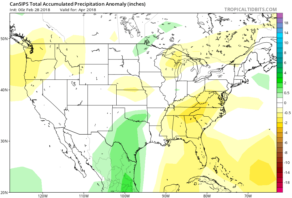
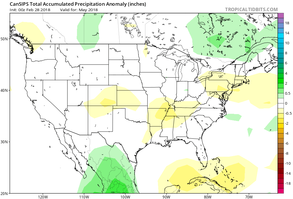
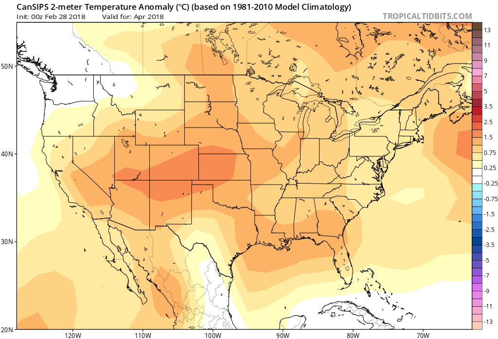
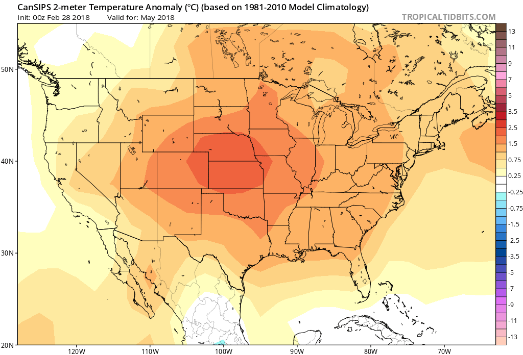
The dominant global weather feature currently is a weakening La Nina condition across the eastern tropical Pacific which tends to promote a pattern of warmer than normal temperatures and dryer than normal conditions in the eastern US. However there are other factors that tend to promote cooler and wetter than normal conditions in the eastern US. When adding up all the factors the expectation for April and May is to be slightly warmer than normal with below normal rainfall in April and near normal rainfall in May.
Please be advised that Region 1 = Richmond area; Region 2 = Va Beach; Region 3 = Clayton, NC; Region 4 = Jacksonville, NC; Region 5 = Greenville, SC
Forecast discussion day 3 – 5 (14 Mar – 16 Mar) Temperatures below normal early, near normal late in period; mostly dry conditions all regions through period. Cooler air moves into the forecast area as a low pressure system exits to the east. There is a significant chance of overnight below freezing temperatures especially early in the period. Conditions stay mostly dry with only a slight chance of scattered rain/snow showers early in the period for Region 1 (Richmond area). Precipitation amounts will likely be in the 0.00 – 0.05” range, with the greatest chance of precipitation in Region 1.
Temperature Forecast and Climatology:
| Region and Rep Station | Fcst High T Range | Climo High T | Fcst Low T Range | Climo Low T | |
| Reg 1 Richmond VA | 55-58 | 60 | 25-40 | 38 | |
| Reg 2 VA Beach VA | 44-58 | 58 | 27-40 | 42 | |
| Reg 3 Clayton NC | 46-62 | 64 | 28-34 | 41 | |
| Reg 4 Jacksonville NC | 48-63 | 65 | 29-44 | 44 | |
| Reg 5 Greenville SC | 47-65 | 64 | 28-45 | 43 |
Forecast discussion day 6 – 8: (17 Mar – 19 Mar) Temperatures warm to slightly above normal all regions; scattered showers all period. Expect a series of weak systems to move through the forecast area through the period. This will keep temperatures slightly above normal and cause periods of rain showers throughout the period. Precipitation amounts will likely be in the 0.20 – 0.40” range for most locations.
Temperature Forecast and Climatology:
| Region and Rep Station | Fcst High T Range | Climo High T | Fcst Low T Range | Climo Low T | |
| Reg 1 Richmond VA | 62-68 | 61 | 43-51 | 39 | |
| Reg 2 VA Beach VA | 62-65 | 59 | 47-51 | 43 | |
| Reg 3 Clayton NC | 67-71 | 65 | 42-55 | 42 | |
| Reg 4 Jackson NC | 66-73 | 66 | 44-53 | 45 | |
| Reg 5 Greenville SC | 68-73 | 65 | 48-58 | 47 |
Forecast discussion day 9 – 11: (20 Mar – 22 Mar) Temperatures cool to near normal; scattered showers all regions mid period. Cooler air moves into the forecast area as a low pressure system exits to the east and cold high pressure system moves in from the NW. There is a chance of overnight below freezing temperatures in region 1. Conditions stay mostly dry. Precipitation amounts will likely be 0.10 – 0.25” range.

Temperature Forecast and Climatology:
| Region and Rep Station | Fcst High T Range | Climo High T | Fcst Low T Range | Climo Low T | |
| Reg 1 Richmond VA | 60-62 | 62 | 35-42 | 40 | |
| Reg 2 VA Beach VA | 57-61 | 60 | 40-46 | 44 | |
| Reg 3 Clayton NC | 64-66 | 66 | 39-43 | 43 | |
| Reg 4 Jackson NC | 66-68 | 67 | 45-47 | 46 | |
| Reg 5 Greenville SC | 64-66 | 66 | 44-46 | 45 |
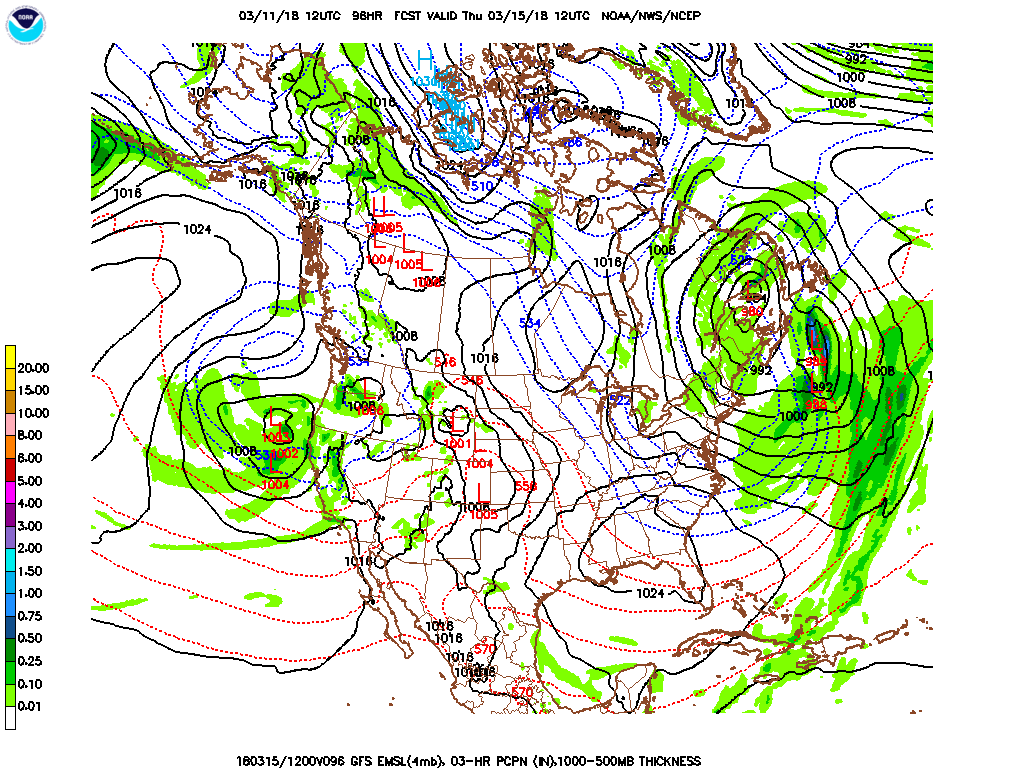
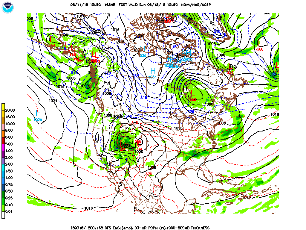
Forecast discussion day 12 – 14: (23 Mar – 25 Mar) Temperatures warm to above normal all regions; widespread showers mid to late period. Expect strong low pressure and frontal system to approach the forecast area through the period. This will allow a strong southwesterly flow to develop warming temperatures to above normal. The approaching front is expected to be strong and will likely cause periods of widespread rain mid to late in the period. This weather pattern has the strong possibility of triggering severe thunderstorms and even the chance for tornadoes as it moves through the forecast region late in the period. Precipitation amounts will likely be in the 0.50 – 0.75” range for most locations.

Temperature Forecast and Climatology:
| Region and Rep Station | Fcst High T Range | Climo High T | Fcst Low T Range | Climo Low T | |
| Reg 1 Richmond VA | 64-69 | 63 | 43-48 | 41 | |
| Reg 2 VA Beach VA | 63-68 | 61 | 48-51 | 45 | |
| Reg 3 Clayton NC | 67-77 | 67 | 47-50 | 44 | |
| Reg 4 Jackson NC | 69-78 | 68 | 50-53 | 47 | |
| Reg 5 Greenville SC | 68-75 | 67 | 48-50 | 46 |
Day 15 – 22 Outlook (26 Mar – 1 Apr): Early indications are that temperatures will be above average with the precipitation below the seasonal average during this period.
Day 23 – 30 Outlook (2 Apr – 8 Apr) Early indications are that temperatures will be above the seasonal average during this period with precipitation below normal.
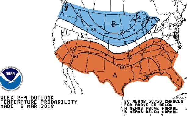
Day 15 – 30 Temperature Outlook 26 Mar – 8 Apr
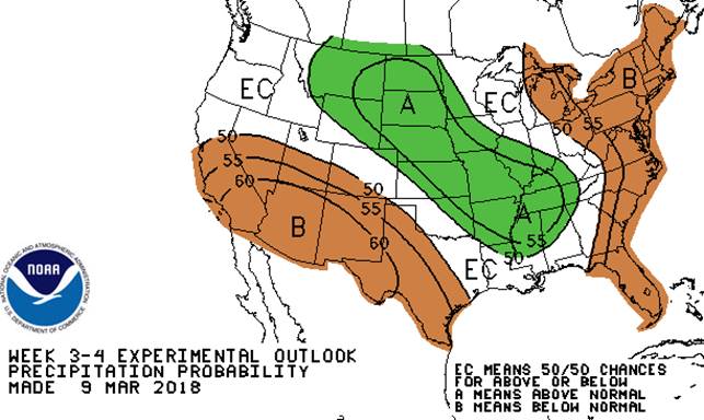
Day 15 – 30 Precipitation Outlook 26 Mar – 8 Apr
 April and May Temperature Anomalies
April and May Precipitation Anomalies