


Some Eastern NC Areas Will Likely See Frost Again Saturday Morning (5pm, Friday, March 9, 2018)
go.ncsu.edu/readext?515263
en Español / em Português
El inglés es el idioma de control de esta página. En la medida en que haya algún conflicto entre la traducción al inglés y la traducción, el inglés prevalece.
Al hacer clic en el enlace de traducción se activa un servicio de traducción gratuito para convertir la página al español. Al igual que con cualquier traducción por Internet, la conversión no es sensible al contexto y puede que no traduzca el texto en su significado original. NC State Extension no garantiza la exactitud del texto traducido. Por favor, tenga en cuenta que algunas aplicaciones y/o servicios pueden no funcionar como se espera cuando se traducen.
Português
Inglês é o idioma de controle desta página. Na medida que haja algum conflito entre o texto original em Inglês e a tradução, o Inglês prevalece.
Ao clicar no link de tradução, um serviço gratuito de tradução será ativado para converter a página para o Português. Como em qualquer tradução pela internet, a conversão não é sensivel ao contexto e pode não ocorrer a tradução para o significado orginal. O serviço de Extensão da Carolina do Norte (NC State Extension) não garante a exatidão do texto traduzido. Por favor, observe que algumas funções ou serviços podem não funcionar como esperado após a tradução.
English
English is the controlling language of this page. To the extent there is any conflict between the English text and the translation, English controls.
Clicking on the translation link activates a free translation service to convert the page to Spanish. As with any Internet translation, the conversion is not context-sensitive and may not translate the text to its original meaning. NC State Extension does not guarantee the accuracy of the translated text. Please note that some applications and/or services may not function as expected when translated.
Collapse ▲Good afternoon,
In a quick review of AWIS Hourly Forecasts for locations across North Carolina, I did note that Fayetteville Fayetteville 3.10 and Elizabethtown Elizabethtown are potentially going to see frost Saturday morning. And, what is interesting to note is that the minimum air temp. for Elizabethtown will only be 36 F (at weather shelter height of 2 meters, or 6.56 ft).
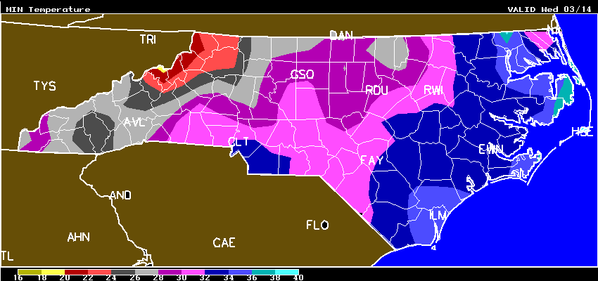
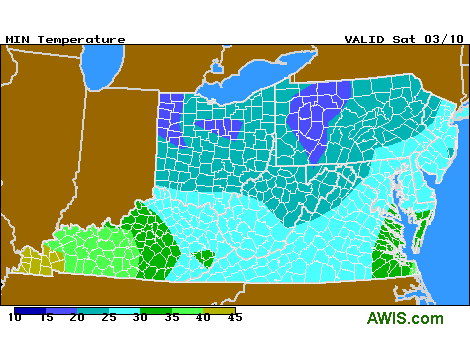
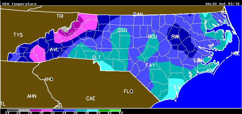 Fig. 1. Minimum temperatures for North Carolina on Saturday morning
Recap of this last night and this morning: In speaking to a grower in Kinston area I learned that there was a BIG FROST this Friday morning, and frost started as early as 2 a.m. Apparently, blossoms in direct contact with the cover were killed. Maybe the Louisiana “raised cover” system is starting to make a little more sense (Fig. 2)? It was also the case that running the drip under cover helped last night. In Kinston area it got down into the range of 26 F. Over in piedmont, I saw one grower location near Greensboro that got down to 23 F this morning (yikes). Once you get to 24 F, you have pretty much run out of all safety margin with a 1 or 1.2 oz cover. That’s double-cover time, or possibly run the drip system to try to gain another a degree of protection. The best tool to tell you the true blossom temperature is a digital thermometer with thermocouple that is inserted in blossom (Fig. 3)/
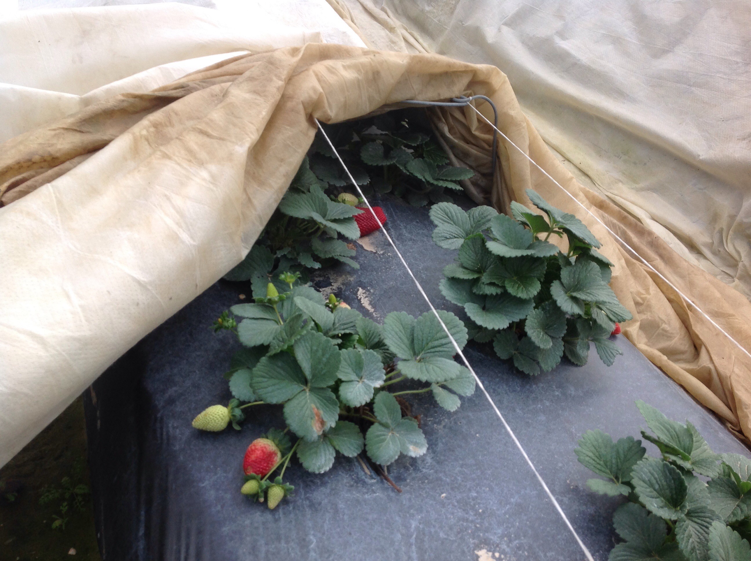 Fig. 2. By providing a support structure to raise the cover, growers in LA can eliminate any frost losses due to blossoms coming in direct contact with the cover.
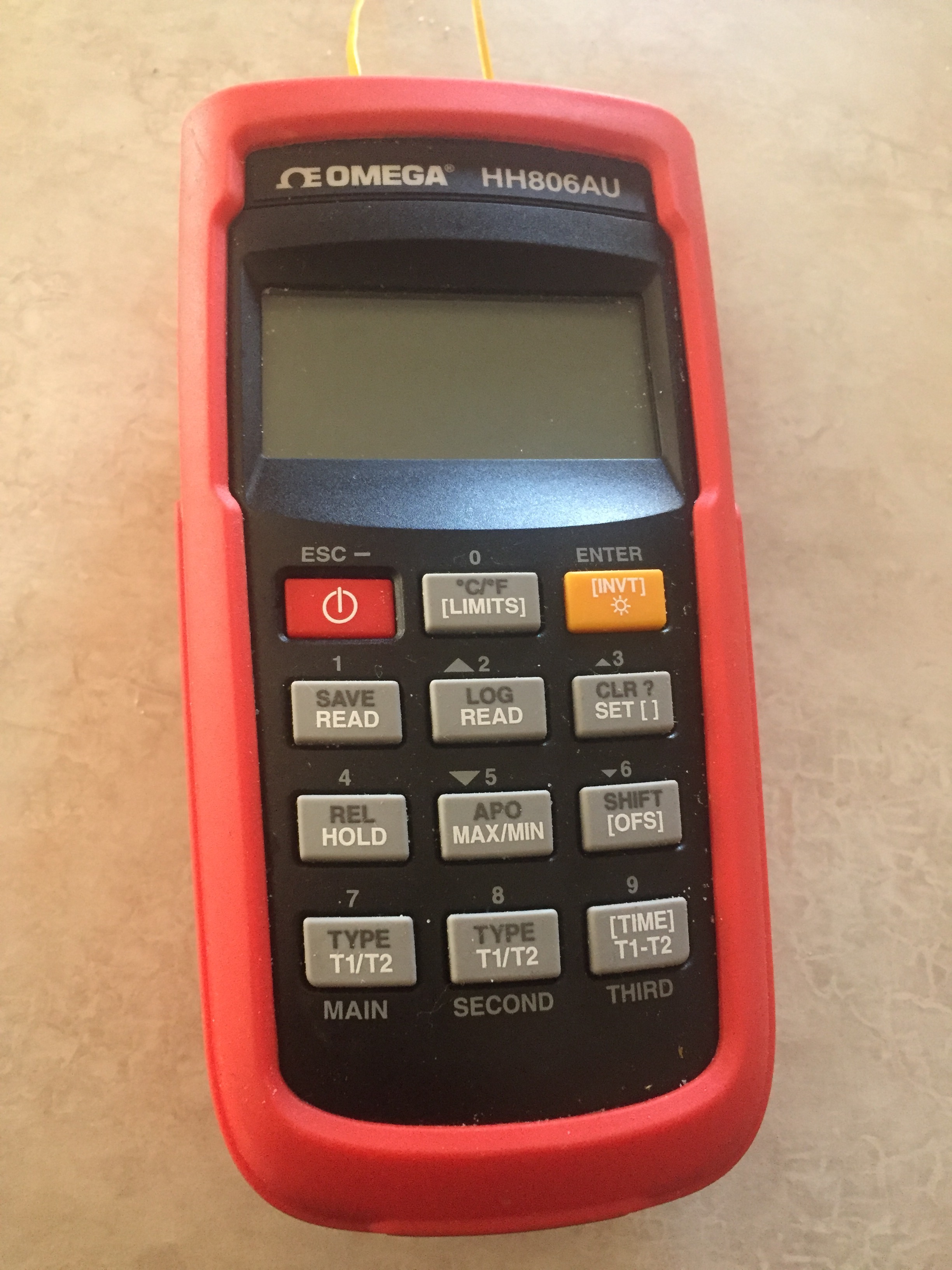
Fig. 3. Digital thermometer is a very useful tool for accurately determining blossom temperature. This unit cost about $232 before tax.
Photos from Chesnee, SC today at 2 p.m.
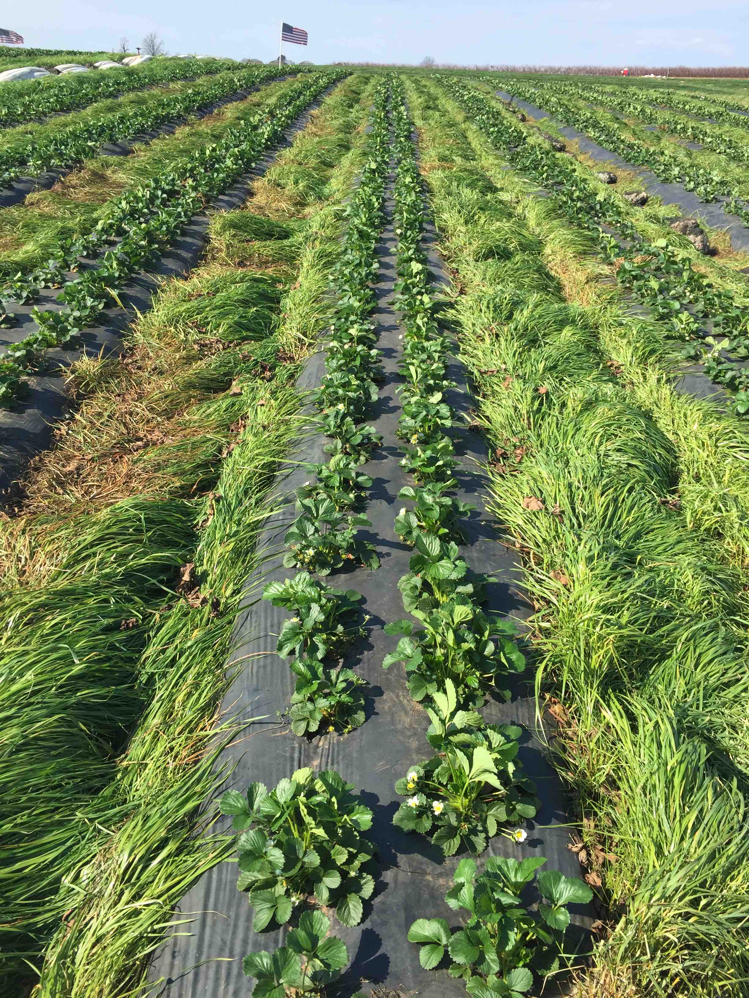
Fig. 4. Camarosa fresh dugs (from PEI) with about 15 blossoms/plant – covers just came off today. The entire acreage at this farm location in Chesnee, SC, had row cover protection – you can see covers off to the side.
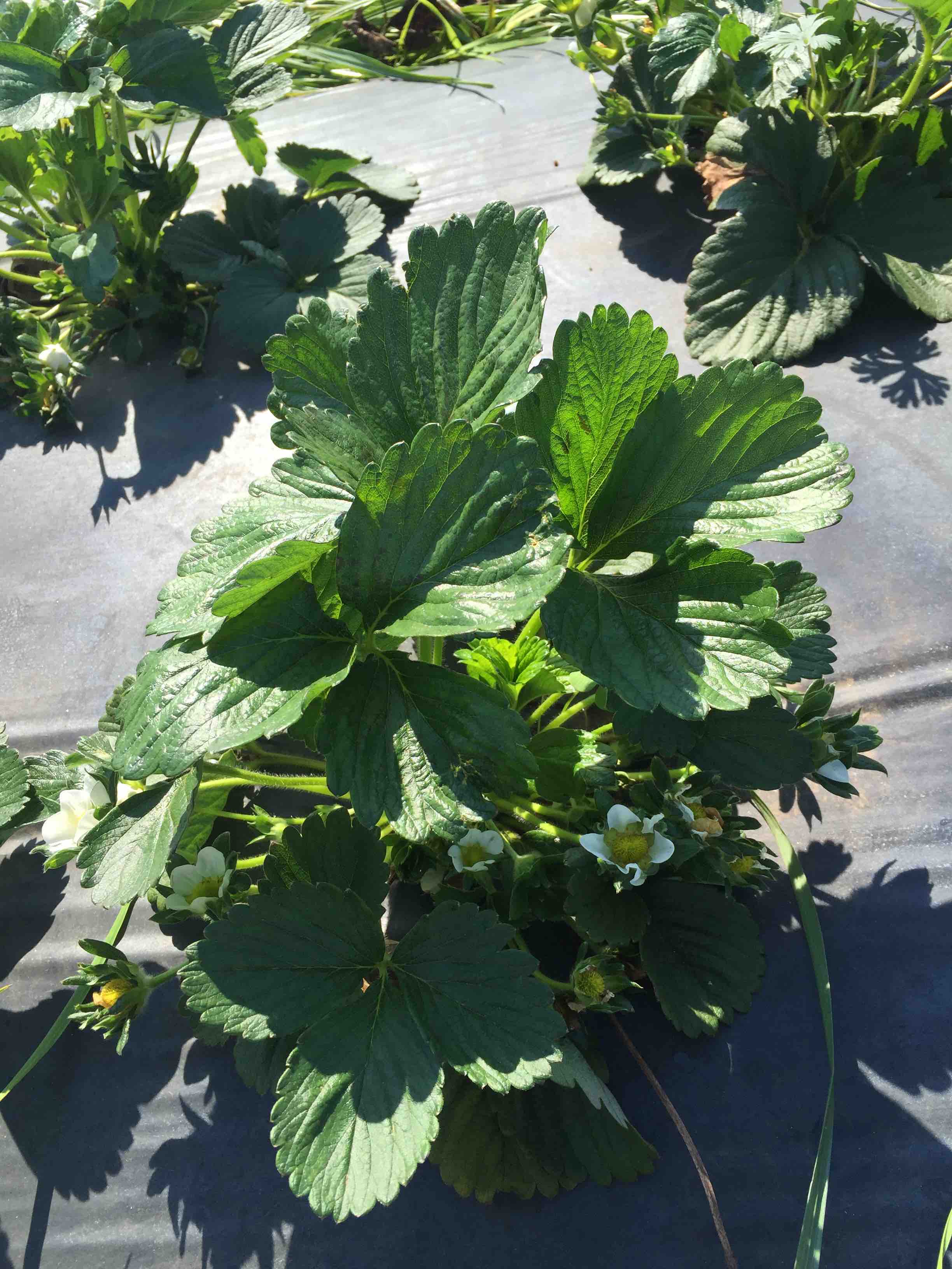
Fig. 5. Close-up of Camarosa fresh dugs — obviously these blooms survived the recent frost events. By far, the fresh dugs are the most advanced in plant size and bloom.
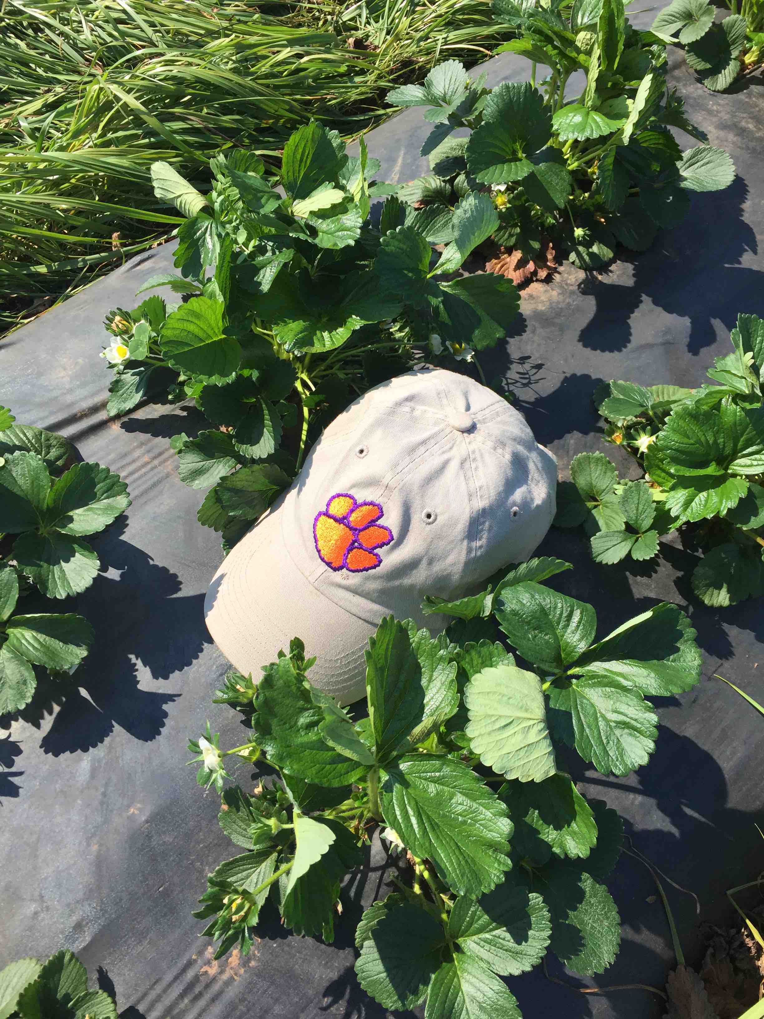 Fig. 6. Cut-offs of Camarosa had about 3-5 blooms today -sorry about the cap Wolf Pack fans.
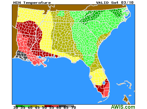
Here is the NC Frost/Freeze Forecast for tonight
AWIS Weather Services, Inc. North Carolina Frost/Freeze Forecast
Produced at  306 p.m. CST on Fri Mar  9 2018

... Forecast for Tonight ... Northeast NC Coast
Currituck/Camden/Pasquotank/Tyrrell Counties

**** NEAR FREEZING COLD LOCATIONS  ****
**** LITTLE/NO FROST DUE TO DRY AIR ****

Lowest Temperatures:      35 - 41
Elizabeth_City Min          35
Range Dewpoint Temps:     19 - 31
Range Wetbulb  Temps:     31 - 38
AVG Wind Direction/Speed:  SW  5     Long Periods of Calm
AVG Sky Condition:     Partly Cloudy

Extended Forecast: Range of Lowest Min Temperatures in the Above Zones
Min Temps Valid For Morning of Given Date (May NOT include ALL cold pockets)

  03/11/18  03/12/18  03/13/18  03/14/18  03/15/18  03/16/18
  --------  --------  --------  --------  --------  --------
   40 - 48   38 - 44   34 - 40   32 - 38   34 - 40   39 - 45
--------

East Central/SE NC Coast
Carteret/Pamlico Counties

**** NEAR FREEZING COLD LOCATIONS  ****
**** LITTLE IF ANY FROST ****

Lowest Temperatures:      34 - 39
Morehead_City Min           39
Range Dewpoint Temps:     24 - 34
Range Wetbulb  Temps:     32 - 39
AVG Wind Direction/Speed:  SW  5     Periods of Calm
AVG Sky Condition:     Mostly Cloudy

Extended Forecast: Range of Lowest Min Temperatures in the Above Zones
Min Temps Valid For Morning of Given Date (May NOT include ALL cold pockets)

  03/11/18  03/12/18  03/13/18  03/14/18  03/15/18  03/16/18
  --------  --------  --------  --------  --------  --------
   45 - 47   40 - 42   34 - 37   32 - 35   30 - 34   35 - 43
--------

Southeast NC
NWS FORECAST ZONES 87-90,96-101

**** NEAR FREEZING COLD LOCATIONS  ****
**** LITTLE/NO FROST DUE TO DRY AIR ****

Lowest Temperatures:      35 - 40
Elizabethtown Min           38
Range Dewpoint Temps:     20 - 34
Range Wetbulb  Temps:     35 - 40
AVG Wind Direction/Speed:  SW  5     Long Periods of Calm
AVG Sky Condition:     Mostly Cloudy

Extended Forecast: Range of Lowest Min Temperatures in the Above Zones
Min Temps Valid For Morning of Given Date (May NOT include ALL cold pockets)

  03/11/18  03/12/18  03/13/18  03/14/18  03/15/18  03/16/18
  --------  --------  --------  --------  --------  --------
   45 - 49   37 - 44   32 - 35   31 - 35   28 - 33   36 - 40
--------

North-Central NC
Franklin County Area

**** FREEZE COLD LOCATIONS  ****
**** LITTLE IF ANY FROST DUE TO CLOUDS ****

Lowest Temperatures:      31 - 39
Louisburg Min               31
Durations at/below 32:     0 -  2
Range Dewpoint Temps:     17 - 27
Range Wetbulb  Temps:     28 - 37
AVG Wind Direction/Speed:   V  2     Long Periods of Calm
AVG Sky Condition:         Cloudy

Extended Forecast: Range of Lowest Min Temperatures in the Above Zones
Min Temps Valid For Morning of Given Date (May NOT include ALL cold pockets)

  03/11/18  03/12/18  03/13/18  03/14/18  03/15/18  03/16/18
  --------  --------  --------  --------  --------  --------
   36 - 44   28 - 39   27 - 33   24 - 31   25 - 33   33 - 40
--------

North/Central NC
Alamance County Area

**** NEAR FREEZING COLD LOCATIONS  ****
**** LITTLE IF ANY FROST DUE TO CLOUDS ****

Lowest Temperatures:      33 - 38
Graham_AG Min               35
Range Dewpoint Temps:     17 - 27
Range Wetbulb  Temps:     32 - 37
AVG Wind Direction/Speed:  SE  3     Long Periods of Calm
AVG Sky Condition:         Cloudy

Extended Forecast: Range of Lowest Min Temperatures in the Above Zones
Min Temps Valid For Morning of Given Date (May NOT include ALL cold pockets)

  03/11/18  03/12/18  03/13/18  03/14/18  03/15/18  03/16/18
  --------  --------  --------  --------  --------  --------
   38 - 43   29 - 35   27 - 32   26 - 31   26 - 31   35 - 40
--------

South/Central NC
Richmond County Area

**** NEAR FREEZING COLD LOCATIONS  ****
**** LITTLE IF ANY FROST DUE TO CLOUDS ****

Lowest Temperatures:      35 - 38
Ellerbe Min                 38
Range Dewpoint Temps:     20 - 32
Range Wetbulb  Temps:     35 - 38
AVG Wind Direction/Speed:  SW  5     Periods of Calm
AVG Sky Condition:         Cloudy

Extended Forecast: Range of Lowest Min Temperatures in the Above Zones
Min Temps Valid For Morning of Given Date (May NOT include ALL cold pockets)

  03/11/18  03/12/18  03/13/18  03/14/18  03/15/18  03/16/18
  --------  --------  --------  --------  --------  --------
   43 - 47   36 - 39   29 - 34   29 - 33   29 - 31   33 - 39
--------

Interior/EC-SE NC
Wayne County Area

**** NEAR FREEZING COLD LOCATIONS  ****
****    PATCHY FROST  ****

Lowest Temperatures:      33 - 37
Goldsboro_AG Min            36
Range Dewpoint Temps:     21 - 34
Range Wetbulb  Temps:     35 - 38
AVG Wind Direction/Speed:   V  2     Long Periods of Calm
AVG Sky Condition:     Mostly Cloudy

Extended Forecast: Range of Lowest Min Temperatures in the Above Zones
Min Temps Valid For Morning of Given Date (May NOT include ALL cold pockets)

  03/11/18  03/12/18  03/13/18  03/14/18  03/15/18  03/16/18
  --------  --------  --------  --------  --------  --------
   42 - 46   37 - 40   32 - 34   30 - 33   29 - 32   34 - 41
--------
NC – Growers should note potential “frost activity” again in the mid-week period for next week!
 10-DAY DETAILED HOURLY WEATHER FORECASTS
SC
10-DAY DETAILED HOURLY WEATHER FORECASTS
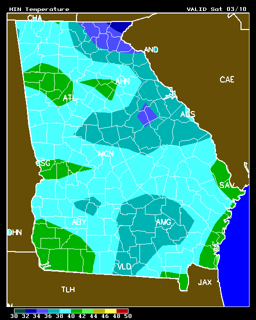
GA
10-DAY DETAILED HOURLY WEATHER FORECASTS
10-DAY DETAILED HOURLY WEATHER FORECASTS
10-DAY DETAILED HOURLY WEATHER FORECASTS
10-DAY DETAILED HOURLY WEATHER FORECASTS
ccc